


10 Days In The Southwest - Part 2
The second in a 3-part (possibly 4-part) series detailing my recent trip through Zion, Bryce and The Grand Canyon

One Stop Over is currently a free publication. However, if you feel the overwhelming urge of generosity sweeping over you and you enjoy my work, you can support me in several ways…
The drive from Page to Jacob lake is only around 80 miles. Our route took us back south along 89 through Navajo Nation where we picked up 89a and headed northwest through a remote and scenic section of northern Arizona. On our way back down through Antelope Pass, we are greeted with a snow/hail squall that swept across the plateau. Low clouds, rain, fog and hail tumbled over the cliff edges, but as we passed back through Bitter Springs and hung a right on 89a to head back north, the weather began to break as we arrived at our first stop. The Navajo Bridge.
Prior to 1929, crossing this dramatic section of the Colorado River required either the use of the ferry further upstream at Lee’s Ferry or an arduous 800 mile detour. When the original bridge opened in 1929, it greatly improved transportation options in the area. At the time of its construction, it was the largest steel arch bridge anywhere in the world and was an engineering marvel that took over 2 years to complete. The original bridge has now been retired and is restricted to pedestrian traffic only, after a newer, wider bridge was constructed starting in 1993. As we walk across the span of the pedestrian bridge we are greeted with a scene that appears like something out of an old western movie. 500ft below, the Colorado moves relentlessly onward, hemmed in on both sides by the sheer cliffs. On the western side of the river, tall sandstone and limestone cliffs reach into the sky and the contrast between their red and purple color and the blue sky is high. As we reach the center of the bridge, a majestic California Condor cruises just over our heads effortlessly using the updrafts before landing on its perch below us on one of the bridge girders. In 1987, the California Condor was officially listed as extinct in the wild when the only surviving 27 wild individual birds were captured and then cared for in captivity with hope to later breed them to rebuild the population through reintroduction. In 1991, the reintroduction program began and to date there are estimated to be over 500 wild birds. And while numbers are continuing to grow they are still considered one of the world's rarest birds that face constant threats from poisoning and habitat loss
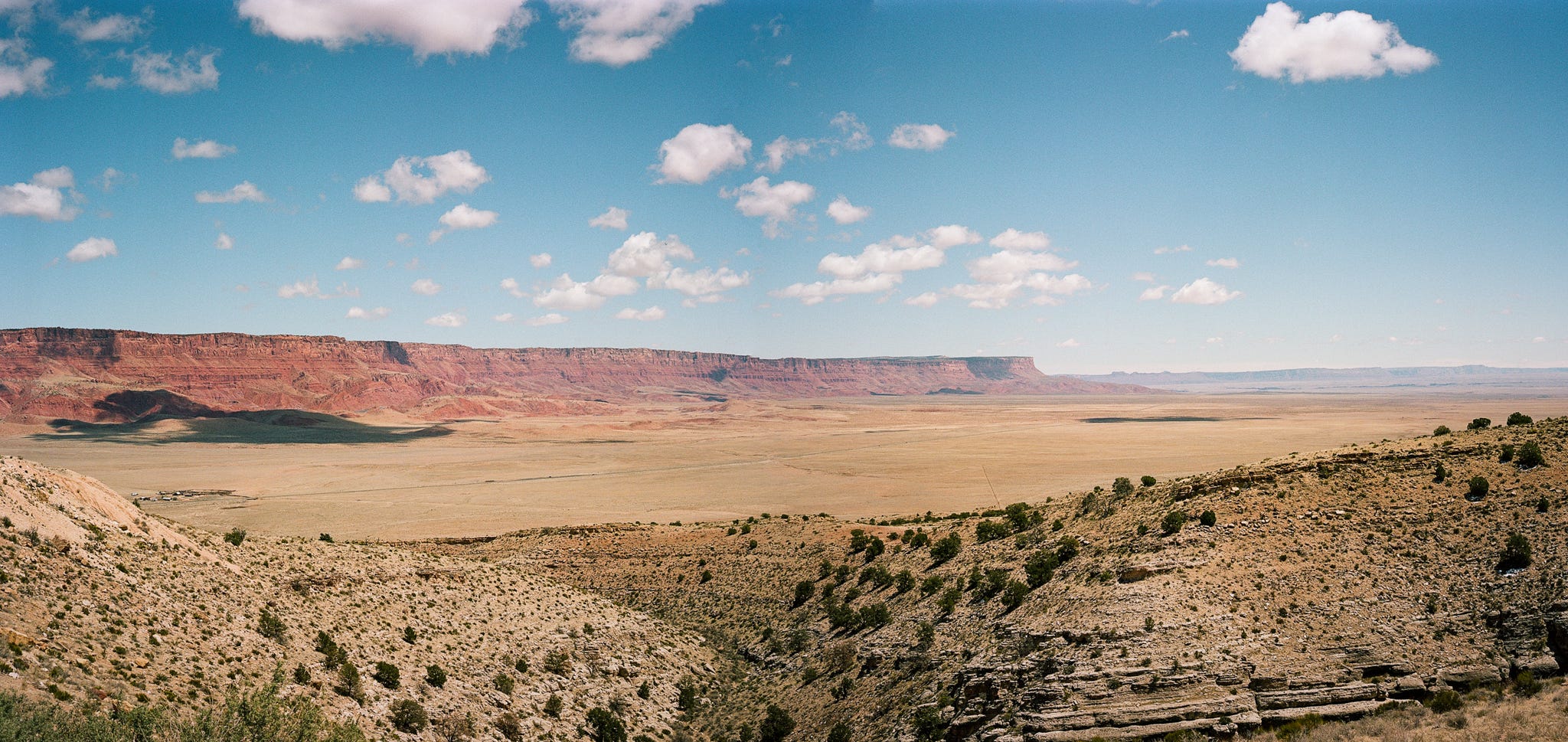
The reason the condors are present in this area is that the Vermillion Cliffs National Monument was picked as a reintroduction site by the Department of Fish and Wildlife. These cliffs watch over you as you continue along 89a. As small puffy cumulus clouds move across the sky casting shadows on the cliffs and the surrounding landscape, there is a constant shift in their vibrancy and color. Reds, Maroons, Purples, Oranges, Greys, Whites and Yellows all appear in the layers of sedimentary rock that make up the land here and as we begin to cross the valley that separates the Vermillion Cliffs from the Kaibab Forest, we decided to take a slight detour and headed north to visit a Condor viewing site on the west side of the plateau that makes up the cliff area. To our east, we see the colored cliffs looming over us some 1500 ft above where we are parked on the floor of the House Rock Valley. To the west the valley floor slowly rises to the rolling hills of the Kaibab forest which appear almost monotone in comparison to the cliffs. They are made up of limestone hills, dotted with Ponderosa Pine, Douglas fir, Aspen, Blue Spruce, Oak, Pinyon Pine, and Juniper. The following day we would return to this section of the wilderness and head further along the road that took us north to the Condor viewing site, but for now we double back and head into the hills and make our way along the final stretch of our drive to Jacob Lake. The open desert vistas give way to a more Alpine environment, and a rain and snow squall moves through the area as we climb the higher elevations toward our stop for the night. I’m less amazed at how quickly the weather can change here in the US these days because I’ve come to realize that volatile meteorology is part of the American experience, especially in the vast landscapes of the west. Over the years of living here I’ve come to realize that in most places, you need to account for every season during every season. However, what amazes me is the dramatic change in geography and geology. The sheer forces of nature that would have been present to create such contrast seem unmeasurable to my mind. The timeline of earth’s creation is on full display.
Jacob Lake. Elevation 7,920 feet above sea level. Population… unknown. Located in rural Coconino county, Arizona on the Kaibab Plateau. This small town, centered around the Jacob Lake Inn, calls itself the “Gateway To The Grand Canyon”. The inn sits at the intersection of routes 89a and 67 (The Grand Canyon Highway) and provides direct access to the North Rim areas of the Grand Canyon. We had 2 full days in this area with the express intent of exploring the North Rim. Yet, despite meticulous planning we had somehow failed to notice that prior to May the north rim national park area was closed to visitors! So, a couple of weeks before the trip, when we realized this was the case, and our accommodation was booked we decided that despite the oversight on our part we would stick to the original plan, stay at the inn and just explore the surrounding area before moving on to Zion in 2 days.
We arrived at the hotel, checked in, warmed ourselves by the open fire in the hotel lobby and drooled over the world famous cookies on display. If you want peace, quiet and solitude, a place like Jacob Lake is a fantastic choice prior to the start of the north rim season. There were only a few other guests staying at the time and on the first night, we had the dinette area to ourselves where we ate simple but delicious sandwiches and cookies and spent time chatting with one of the seasonal employees that was there helping get ready for the full season. He spent time telling us about the history of the inn, the surrounding area and had some great recommendations for the later stages of our trip when we would be in Zion and Bryce. With full bellies, we retired to our room to get an early night after a full day of activities.
Due to our error in park scheduling, we had another full day and night in Jacob Lake. I awoke early the next morning (something I seem to do no matter what time I go to bed these days) and was greeted by the wonderful sight of about 6 inches of fresh snow on the ground. The sun was not yet up but blue hour had begun and the light danced between the tall Ponderosa Pines and bounced off the snow making it seem lighter outside than it was. I decided to throw on some warm clothes, grab my camera and head out into the woods to capture some early morning snow shots in the forest. The stillness that I experienced that morning was like nothing I've ever felt. Not a breath of air, the occasional thump of snow falling to the ground as the sun warmed the tops of the trees enough to begin melting it. But almost the total stillness of the forest.
I headed back to the lobby of the inn by 8am to grab some coffee for the rest of the family before getting everyone up and ready for the day ahead. With fresh snow still on the ground we started the day with a hike out through a trail in the woods which would take us to the famed Lake (which is more like a large frozen puddle these days) and to the old ranger station that was originally used in this area. We were lucky enough to catch sight of the elusive Kaibab Squirrel with his long sweeping ears, dark fur and bushy white tail. We looped back to the hotel, refilled our coffee and then headed back east toward the Condor viewing site where we had been the day before. It didn’t take much of a drop in elevation for the snow to give way to the sun and we went from 18f to 60f in a span of only a few miles. Today, our goal was to drive further north of the viewing site, along House Rock Valley Road and stop at several of the area’s short hikes. We spent the day hiking up to ancient petroglyphs at the Maze Rock Art site and driving various other off-road trails in the area, something we would have not been able to do without a well equipped 4x4. We encountered only a few other hikers the entire day and the solitude and family time alone was something we all needed. Sometimes, on vacation, and in an effort to see and do things that meet everyone’s tastes you often find yourself surrounded by other families doing the same thing. I think the experience we had, navigating unmarked, rutted out trails in our Jeep, all of which seemed to have signage warning us that they were “Not The Route To White Pocket” will be something that we will cherish forever. And for me, despite the grandeur of Zion and Bryce (which at this point we had not yet experienced), it was time away from crowds with my family that I found the most joy in during our time away. The following morning we would load up the car early, leave Jacob Lake behind and head onward to Zion and Bryce.
Here’s a selection of images from this section of our trip. This is a combo of 35mm and 120 Kodak Gold 200 and Kodak Porta 160. Developed and scanned at home and with the assistance of Gelatin Labs.


Thanks for reading this weeks post. As you know if you been listening to my audio recordings I’ve also started to highlight a few of the other great Substack newsletters that I’ve come across recently. Here are my picks for this week:
Just Suzy:

Emma Schneck:

What a cool place. I somewhere managed to unsubscribe from you by accident so I’m happy to find you again!
Lovely images Tom, I particularly love the green gate and the tree.